TABLE OF CONTENTS
Live Map shows the employee's location in real time. In general, Live Map is similar to Time Card Review Map. We draw the employee's daily activity — where he/she was, at what type of location, whether he/she entered the site or not.
But the main feature and difference of Live Map is that we can monitor the employee's work activity in real time.
Access to Live Map
| Live Map dashboard | Map tab Daily Dashboard | Map tab Dispatch Calendar |
| All Users | FSMFinancial user group | All Users |
How it works
As you know, the clocked-in device sends us logs every 10 minutes. These logs contain all the data to build the employee's movement route. Once we get the geodata from the device, we process this data to understand where the employee is.
With a certain algorithm, we define Stops, look for Sites, Locations close to Stops, and finally calculate Drives.
Let us look at the algorithm in more detail.
1. It takes the Employee's location information sent from the clocked-in device.
Since the device sends logs every 10 minutes, each log set contains an array of Employee's movement route – GPS Points.
2. Defining periods of No GPS activity.
No GPS is a period during which there is not a single GPS point.
If there is a point, but the interval before and after it is more than 5 minutes (configurable part), then the algorithm cannot determine where the employee has moved to. Such a period is also NO GPS.
3. Processing of continuous periods — periods with GPS points: define Stops.
The algorithm calculates the average velocity — displacement between points within 5 minutes.
From the result, it determines:
- Stops — if v < 1 km/h
- Slow Drives — 1 km/h <v < 10 km/h
5. Processing Stops inside polygons.
Once the Stops have been identified, the next step is to define the intersection with Sites, Locations polygons.
Stops at Sites:
- that has a scheduled Work Order,
- it is a related Site to a scheduled WO,
- that has a WO for an unscheduled visit,
- it is a related Site to a WO for an unscheduled visit,
- it is a Site if a Carrier Group Sites,
- it is a Site that has at least one Build Plan
Stops at Office/Warehouse — Stops within the polygon of the Warehouse location type.
The Site/Location boundary is set on the Site and Location card respectively.
The Default Site boundary is a radius of 300 meters, Location — radius of 100 meters.
A Site/Location with 0 radius is excluded.
Stops at Known Locations — Stops within the boundary of any other known location (Employee Homes, Material Suppliers, Remote Hotel, etc.).
The Stops and Slow Drives within the polygon of a Site or Location are merged into one Stop. This merged stop is displayed on the map and on the timeline.
6. Processing Stops outside polygons.
Unknown Stops — Stops outside the Site or Location polygons. For this kind of stops the algorithm will calculate a geometric center (point) of these points within a 100-meter radius.
You can use the map tools to display objects in the area of an unknown stop.
7. All other periods that are not Stops are considered by the algorithm as Drives.
Short Drives of 1 minute are distributed to adjacent stops.
Live Map Interface
You can open Live Map in many ways:
- Through the Dispatch Calendar. Right-click on Dispatch → select “Show Day on Map” to see the Employee's Location in the selected Dispatch.
- Through the Daily Dashboard. Go to the Live Map Tab to see Employee's Location in the selected Build Plan.
- Directly through the Live Map Dashboard. Open the Dashboard's Home Page → select Live Map.

General


Filters
Basically, we show data on the map based on:
- your current date and time (Live Map Dashboard)
- date selected (Daily Dashboard Live Map)
- date of Dispatch (Dispatch Calendar)
But you can clear the filter and apply a different one. Filter by BP Owners, Crew Members and Build Plans are not available in the Daily Dashboard Live Map.
If you select the past dates, the map will show you the time cards that have been processed: with the corresponding cost types.
The Snapshot is the last time when the map was refreshed.

Employee Day Log Control Field and Map
Here we show a list of Employees for whom we have any geodata on the selected day. We group them by the clocked-in device. Each Employee has a Day Log of activity where we show his stops, drives, scheduled WOs, clock-in and clock-out time and so on.

If you pin more than one employee's daily log to the map, each will be assigned a different color. This is useful if you want to compare day logs. But remember, the more people you pin on the map, the slower the map will work.

Pin the Employee's Day Log on the map.

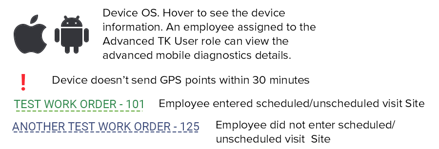
Day Log Legend
Map Legend
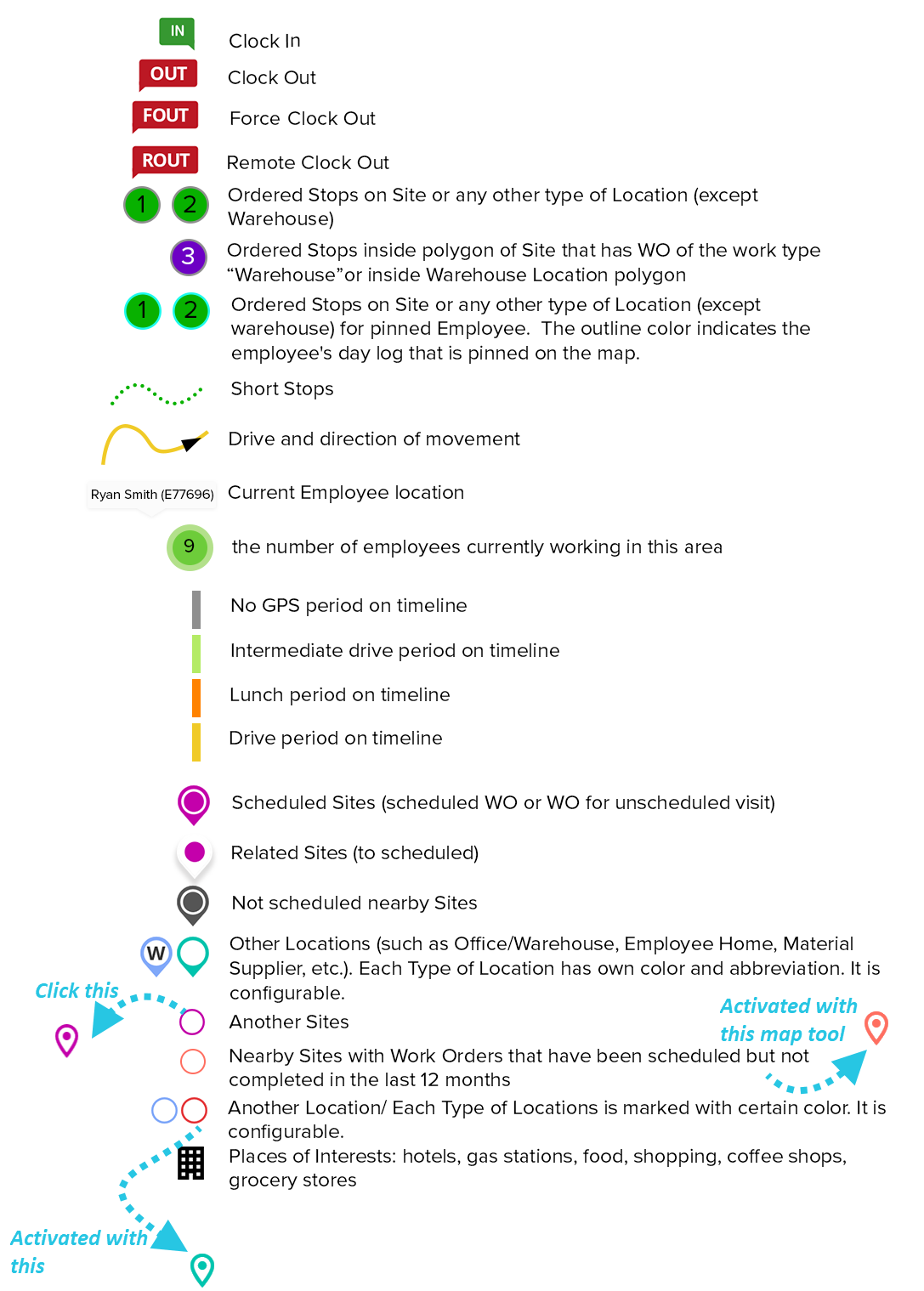
As we mentioned before, you can customize Location Type icons on the map, specify color and abbreviation. The icon contains 1 letter, the color must be set in HEX format.
Was this article helpful?
That’s Great!
Thank you for your feedback
Sorry! We couldn't be helpful
Thank you for your feedback
Feedback sent
We appreciate your effort and will try to fix the article